London, GB | Formerly of New York, Buenos Aires, Fife, and the Western Cape. | Saoránach d’Éirinn.

About Andrew Cusack
 Writer, web designer, etc.; born in New York; educated in Argentina, Scotland, and South Africa; now based in London.
 read more
News
Blogs
Reviews & Periodicals
Arts & Design
World
France
Mitteleuropa
Knickerbockers
Argentina
The Levant
Africa
Cape of Good Hope
Netherlands
Scandinavia
Québec
India
Muscovy
Germany
Academica
‘German’ Poland vs. ‘Russian’ Poland
A curiosity of the 2007 Polish parliamentary election

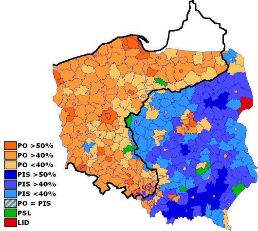
THIS MAP displaying the results of the 2007 general election for the Polish parliament is overlaid with an outline of the nineteenth-century border between the German and Russian empires.
The areas formerly ruled by the German Kaiser tend to back the right-wing liberal Platforma Obywatelska (“Civic Platform”) party, while those formerly ruled by the Tsar tend to support the conservative Prawo i Sprawiedliwość (“Law and Justice”) party.
The green represents the centrist-agrarian Polish People’s Party, while the dark red represents the already-defunct “Left and Democrats” coalition.
Source: Strange Maps
Published at 8:24 pm on Wednesday 17 December 2008. Categories: Germany History Politics Russia Tags: Germany, Maps, Poland, Politics, Russia.
Search
Instagram: @andcusack
Click here for my Instagram photos.Most Recent Posts
- Christ Church December 29, 2024
- A Christmas Gift from the Governor December 24, 2024
- Oude Kerk, Amsterdam December 24, 2024
- Gellner’s Prague December 19, 2024
- Monsieur Bayrou December 18, 2024
Most Recent Comments
Book Wishlist
Monthly Archives
Categories
Home | About | Contact | Paginated Index | Twitter | Facebook | RSS/Atom Feed
andrewcusack.com | © Andrew Cusack 2004-present (Unless otherwise stated)


Great map. I wonder what a “right-wing liberal” stands for?
There is one oversight: the south east part of Poland was a part of the Austro-Hungarian Empire, never a part of Russia.
However, differences between regions which were ruled before 1918 by the three empires are quite strong even today.
Unfortunately, explaining the current state of the Polish politics, which is continuously influenced by the distasteful ‘shadows of PRL’,is rather hard work. Simple questions in Poland are not so simple like they seem to be – the awful truth.
So do the people in ‘Orange-State Poland’ complain about the people in ‘Blue-State Poland’?
Very interesting!
With the iron curtain descended across Europe, I went through my teens and everything knowing nothing of what happened in the former German immediately after the War. I was shocked when I found out about the mass expulsions, and worse (though hardly surprised); I wonder what German remnant there still is in Poland.
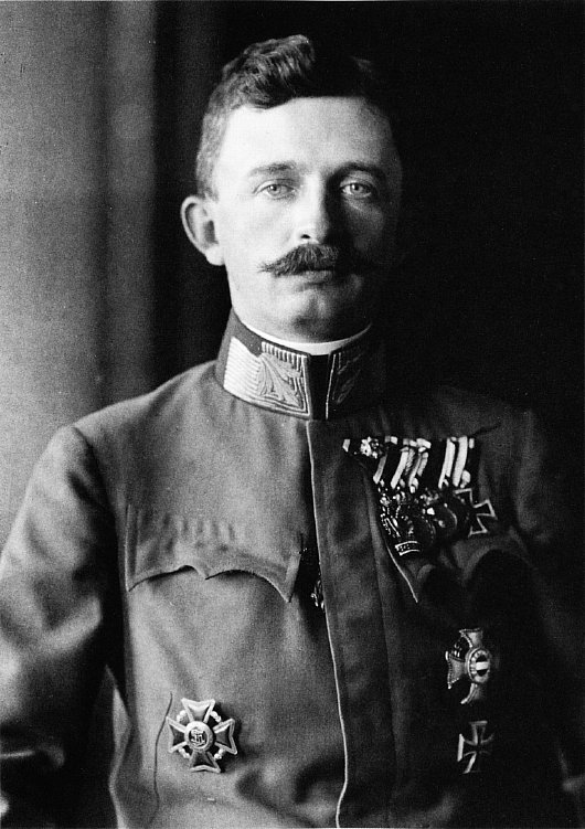
Yes Brunopolski, that region is Galicja, the land my paternal grandmother’s family who emigrated during Blessed Karl’s reign.
To be honest with you, this map exaggerates somehow the actual state, for example, the east part of Poland has less citizens, and PO has won in the vast majority of towns; but it does not mean that this map is no longer interesting.
People do not complain about any part of the country, they complain about the other people.
German remnants in Poland: communists were persistently and wantonly destroying them, especially during the first ten years after the War, like every other remains of non-communistic times – they were called ‘ideologically hostile’. Even bricks from gothic houses from Silesia were used for rebuilding Warsaw. Fortunately, the communists were rather not sedulous. Since mid 60’s people have been taking care of every monument, judging only by its historical and artistic value, not ideology. Of course it normalised actually and finally after 1989.
When it comes to Germans in Poland, they live mainly in south Silesia, in some places there are also bilingual names of places, labels etc.
German Poland/Russian Poland map is interesting.
Have you heard of Budzinsky family;Kraczyk family;
Piontkowski family?
One set of relatives lived in the German Poland and the
other in the Russian Poland.
Thank you.
Your terms German Poland and Russian Poland are inaccurate. Only 1/3 of the orange area is the former German partition, the rest is post-German lands where displaced people from the East live. In the blue area, the bluest southern part is the Austrian partition, not the Russian one.
A more accurate distinction is:
Blue area: native population
Orange area: resettled and Germanized population.